

Visual Navigation
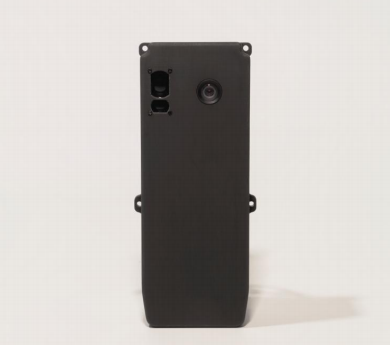

N200:VIO Visual Navigation Module
This product is an AI visual navigation device specifically designed for
drone positioning and navigation under GPS-denied conditions.
It integrates an onboard computer with a high-performance CPU and
6TOPS NPU, a 1080p global shutter camera, and a laser ranging sensor.
The chip computing power and global shutter lens ensure stable ground image
recognition during drone movement.
No pre-installed satellite maps are required: The module uses AI to
analyze visual frame changes and fuses IMU, compass, and other attitude
data from the flight controller to calculate the current relative position, enabling
drone global positioning. Additionally, the laser rangefinder continuously
monitors ground height changes, ensuring adaptability to terrain variations
Key Features:
Ignore to GPS jamming:
Fuses visual/IMU data for GPS-denied waypoint navigation
Executes pre-mapped routes under active EM interference
Precise Navigation:
Navigation accuracy: 2% ~ 8%
Optimized for dynamic scenes, this visual sensor eliminates motion blur
caused by high-speed movement to achieve precise positioning.
Easy to deploy:
Operates without dependency on pre-existing geospatial data
Adheres to MavLink Standard Protocol
No development required—just simple configuration
Compatibility:
Compatible with a variety of drone models
Supports PX4 and APM flight controllers(more platforms coming)